檔案:Corrientes-oceanicas.png

出自六年制學程
跳轉到: 導覽搜尋
完整解析度(1,000 × 522 像素,檔案大小:75 KB,MIME類型:image/png)

該檔案來自於維基共享資源,它可能在其它計劃項目中被應用。 它在檔案描述頁面那邊上的描述於下面顯示。

File:Corrientes-oceanicas-en.svg是本檔案的向量版本。 如果品質不低,就應該優先使用該檔案,而非PNG檔案。

File:Corrientes-oceanicas.png → File:Corrientes-oceanicas-en.svg

更多資訊請參閱Help:SVG/zh

其他語言
Alemannisch  العربية  беларуская (тарашкевіца)  български  বাংলা  català  нохчийн  čeština  dansk  Deutsch  Ελληνικά  English  British English  Esperanto  español  eesti  euskara  فارسی  suomi  français  Frysk  galego  Alemannisch  עברית  hrvatski  magyar  հայերեն  Bahasa Indonesia  Ido  italiano  日本語  ქართული  한국어  lietuvių  македонски  മലയാളം  Bahasa Melayu  norsk bokmål  Plattdüütsch  Nederlands  norsk nynorsk  norsk  occitan  polski  prūsiskan  português  português do Brasil  română  русский  sicilianu  Scots  slovenčina  slovenščina  српски / srpski  svenska  தமிழ்  ไทย  Türkçe  татарча / tatarça  українська  vèneto  Tiếng Việt  中文  中文(中国大陆)  中文(简体)  中文(繁體)  中文(马来西亚)  中文(新加坡)  中文(臺灣)  中文(臺灣)  +/−
新SVG圖片

摘要

描述
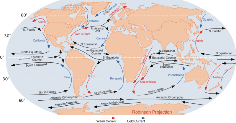
English: the ocean currents.

Note that

  • E. Greenland + Labrador + Norwegian = Viking gyre
  • Gulf stream + N. Atlantic Drift + Canary + N. Equatorial = Columbus gyre
  • S. Equatorial + Brazil + South Atlantic + Benguela = Navigator gyre
  • S. Indian + S. Equatorial + Mozambique + W. Australia = Majid gyre
  • Alaska + N. Pacific + Oyashio = Aloet gyre
  • Kuroshio + N. Equatorial + California = Turtle gyre
  • Peru + S. Pacific + E. Australia = Heyerdahl gyre

Finally, a few gyres also exist at the poles (not shown at this map); these are:

  • North Pole: Polar bear gyre, Storkerson gyre, Melville gyre
  • South Pole: Penguin gyre
References for the currents: Curtis Ebbesmeyer map at Wired
日期
來源 http://blue.utb.edu/paullgj/geog3333/lectures/physgeog.html, original image
作者 Dr. Michael Pidwirny (see http://www.physicalgeography.net)
授權許可
(重用此檔案)
Public domain. U.S. government publication.

授權條款

Public domain
此作品在美國屬於公有領域,因為其是由美國政府的官員或僱員,基於其個人公務目的製作的作品,參考美國法典第17篇第1章第105條
注意︰本模板僅適用於美國聯邦政府的原創作品,不適用於任何美國州屬地、聯邦個體、縣、市或任何次級政府的作品。本模板也不適用於1978年以後美國郵政署出版的郵票圖案(參看美國版權局實踐綱領第313.6(C)(1)條)。也不適用於部分美國硬幣;參看美國鑄幣局使用條款
此作品無已知的著作權限制,亦不受所有相關和鄰接的權利限制。

原始上傳日誌

日期/時間 尺寸 使用者 備⁠註
2007年8月10日, 06:43:09 1000 × 522 (70712 bytes) L30nc1t0 (留言 · 貢獻) {{Information |Description=Imagen de las corrientes oceánicas mundiales. |Source=http://blue.utb.edu/paullgj/geog3333/lectures/physgeog.html |Date=Desconocido |Author=Desconocido |Permission=Desconocido. Entidad pública gubernamental estadounidense. |ot

說明

添加單行說明來描述出檔案所代表的內容
Map of the Earth's major ocean currents

在此檔案描寫的項目

描繪內容

9968e7e46e0ed548c4cdf4fecc4d6ae307c02d72

斷定方法:​SHA-1 中文 (已轉換拼寫)

77,005 位元組

522 像素

1,000 像素

檔案歷史

點擊日期/時間以檢視當時出現過的檔案。

日期/時間縮圖維度使用者註解
目前2014年12月3日 (三) 18:18於2014年12月3日 (三) 18:18的縮圖版本1,000 × 522(75 KB)GifTaggerBot: Converting file to superior PNG file. (Source: Corrientes-oceanicas.gif). This GIF was problematic due to non-greyscale color table.

以下的2個頁面連接到本檔案: